
The Project Maps & Site Plan

Take a closer look to view the project in context to the region, Town of Mammoth Lakes, and the surrounding community.

PROJECT AREA

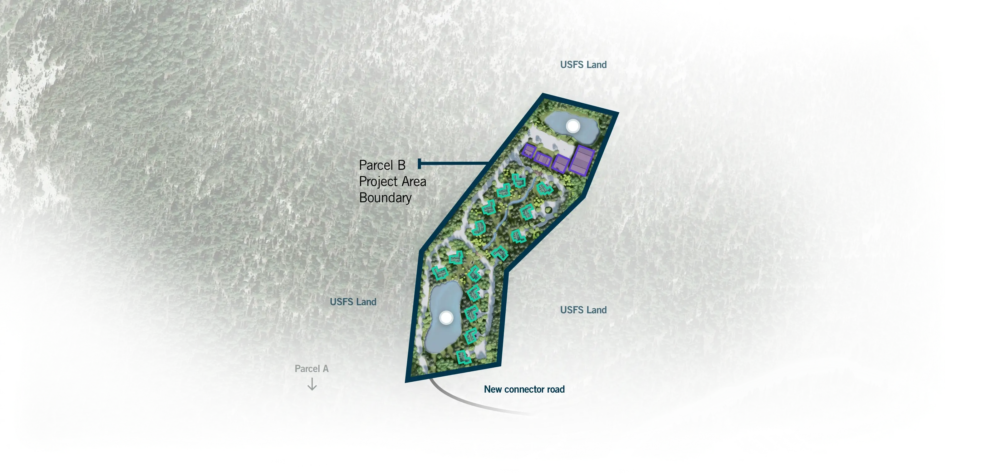
The current plan to enhance the guest experience with new facilities includes improvements on Parcel A and Parcel B as well as surrounding United States Forest Service Land.

The project area map provides a close-up of the two different parcels being studied - Parcels A and B. Each of the parcels is outlined in blue. Parcel B is to the north of Parcel A which includes the current Mammoth Mountain Main Lodge. The outlined areas show where there are proposed new and updated facilities with fresh new amenities. The white areas that are outside of the outlined blue areas include improvements to USFS (United States Forest Service) land. The improvements starting from the north include a New Lift 37 / Platter, new mountain operations at Big Bend, new beginner ski terrain, new Big Bend Relayer, new reservoir improvements up mountain, new skier services and ski beach, realigned gondola, and relocated Discovery Base Terminal. The Town of Mammoth Lakes is to the southeast.

PARCEL B

Parcel B will include new and diverse resort residential options and a water treatment and reclamation facility and storage ponds for snowmaking, summer irrigation and fire suppression.

  • Reclaimed Water Storage Ponds
  • Wastewater Treatment & Facilities
  • Resort Residential
A view of Parcel B with a legend to show new residential and improvement options.

PARCEL A

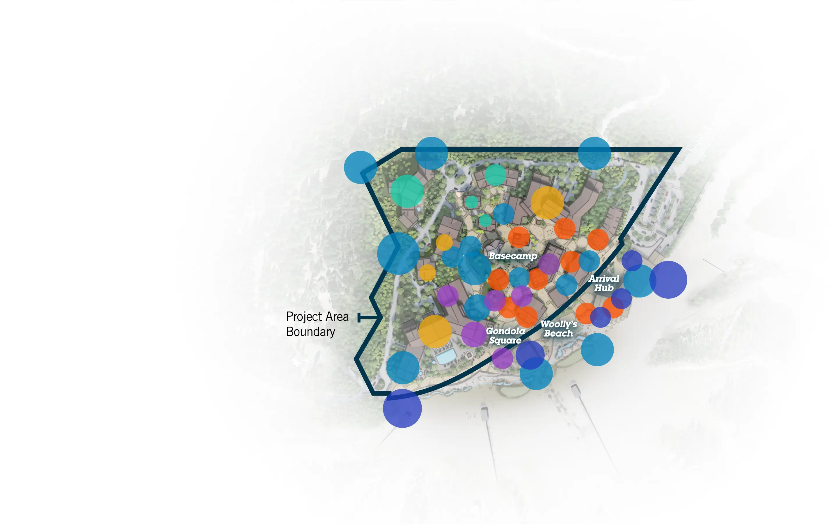
The plan will create a vibrant basecamp on Parcel A offering enhanced guest services and accommodations including new retail, guest amenities and a mix of restaurants and cafes as well as expanded recreation for year-round outdoor experiences.

  • Commercial
  • Resort Residential
  • Lodging / Hotel
  • Mixed Use
A view of Parcel A with outlined elements and a legend to show the uses of the different structures within the project area.

EVOLVING MAIN'S NEW BASECAMP

Integrating existing uses with new facilities to bring new experiences to Main Lodge.

Loading image...
An interactive map to show the different uses within the project areas as well as improvements on USFS land.
The map includes interactive elements to show the placement of different uses within the Parcel A project area. There are six different categories. Each of the categories is a different color. To start all uses are shown on the same map with different colors. This first view shows all of the different uses and the areas where they are located. Amenities / Trail Head are all displayed with blue circles, Restaurants & Cafes are displayed with orange circles, Lodging / Hotel are displayed in yellow, Entertainment / Retail are displayed with purple circles, Resort Residential are displayed with turquoise circles, and On Mountain / Operations are displayed with indigo circles. You are able to use the navigation on the left of the page to change between different uses to see them separately instead of grouped together. When a selection has been made the display of the map will change and show only that selection’s uses including proposed sub-uses under the main category. Below the map, there are five thumbnails displaying illustrated renderings of the main destinations - Basecamp, Gondola Square, Arrival Hub, Woolly’s Beach, and Parcel B. By clicking or tapping on the thumbnail you can view the image in large format.